Pre History
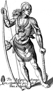
The Susquehannock depicted on the Smith Map in 1609
The North Branch of the Susquehanna River dominates the northeastern portion of Susquehanna County. The river flows south from Windsor, New York, and enters Pennsylvania approximately five miles north of the project area. It runs in a twenty-five-mile-long arc, called the Great Bend, before returning to New York, flowing through Binghamton, on its way to Sayre, where it again enters Pennsylvania.
Previous archaeological research within this portion of the North Branch valley has been minimal (Raber 1985). Thus, reconstruction’s of prehistoric chronology are best based on generalized culture-historical sequences, and on data from nearby areas. As a part of the Susquehanna River drainage, the prehistory of the project area is probably most closely related to the lower reaches and perhaps the West Branch valley, within this same drainage system. The prehistory of Pennsylvania has been traditionally divided into four major periods, the Paleo-Indian, Archaic, Transitional, and Woodland. Categories discussed by Hatch etal. (1985) for the Susquehanna drainage are Paleo-Indian/Early Archaic, Middle Archaic-Early Woodland, and Middle Woodland-Late Woodland. These temporal categories are characterized by differences in the environmental adaptations practiced by human populations. Although such differences are largely ones of changing resource focus, trends in culture change can also be seen to link these periods. For the purposes of this report, the scheme used by Hatch etal. (1985) is followed.
Paleo-Indian/Early Archaic (16,000 BC – 5,000 BC):
The Paleo-Indian Period encompasses the earliest indisputable evidence of human occupation of the North and South American continents. Paleo-Indian populations are believed to have lived in small, kin-based, hunter-gatherer bands and to have hunted cold-adapted animals such as caribou and woodland bison. Fish and plant resources were also presumably important in the diet. Paleo-Indian bands were mobile in response to the location of these food resources including the migration of game animals. In addition, the locations of non-food resources such as lithic materials would have conditioned band mobility patterns.
In the Susquehanna River Valley there is little evidence of Paleo-Indian occupation. With only a few exceptions, Paleo-Indian sites are generally isolated fluted point finds. One of those exceptions is the Shoop Site, located on a flat irregular plateau near Armstrong Creek in Dauphin County. In addition to fluted points, artifacts recovered from the site consist of generalized cutting and scraping tools similar to those found on other Paleo-Indian sites in the Northeastern United States (Witthoft 1952).
Some researchers have proposed combining the Paleo-Indian and Early Archaic Periods because of apparent similarities in adaptation (Gardner 1974, Custer 1985). However, this proposition remains to be tested since we know so little about the distribution of settlements in either period. Stewart (1980) interprets broad settlement patterns from the Hagerstown Valley of Maryland as suggesting a refocusing of hunter-gatherer strategies on new species during the Early Archaic. Such a pattern of changing strategies would be expected given the gradual yet significant changes in the environment throughout the period. Thus, while the Paleo-Indian to Early Archaic Transition may not have involved radical alterations in subsistence-settlement behavior, important adaptive changes may have taken place. Middle Archaic through Early Woodland (5,000 BC – 300 BC): As the climate ameliorated and deciduous forests became established in the study area, hunter-gatherer subsistence was modified to make use of a wide variety of seasonal resources including acorns, nuts, berries, and tubers. Utilized fauna resources included fish, deer, elk, bear, and a variety of small mammals. Ethnographic analogy suggests that hunter-gatherers exploiting these resources were organized into small, egalitarian, seasonal-mobile bands. Related settlement patterns appear to have involved base camps on the valley floor and specialized limited-purpose camps on slopes and at springheads. The special purpose camps appear to have been occupied by task groups engaged in hunting or gathering localized resources. The Middle Archaic climate, warmer and drier than present, may have been somewhat less productive than during later periods. Use of some areas may have been limited due to lace of available surface water. Like earlier periods, however, site data for the Middle Archaic is extremely limited.
The number of archaeological sites increases for the Late Archaic. Although this increase is in part due to the increased visibility of sites, population increase is also believed to have taken place. A consequence of this population increase would have been a decrease in foraging territory available to each band. Several facts support this conclusion. First, a variety of specialized tools have been recovered from archaeological contexts suggesting technological innovations to efficiently exploit locally available resources. Secondly, litchis materials were of a wider variety in both type and quality than in earlier periods, suggesting an increased use of local lithic materials. Finally, dietary data from the northeastern United States suggest that populations added wild seeds to their diet in the Late Archaic Period and began selecting for larger seeds to increase the resource base.
Related to these demographic and subsistence trends was an apparent increase in trade among hunter-gatherer groups. Evidence for trade relationships is strongest in the Mississippi River Valley where copper, galena, and other materials passed through exchange networks. Ethnographic evidence suggests that these trade relationships had political as well as economic functions. The Susquehanna River drainage would have provided a corridor for trade between groups in New York and in the Lower Susquehanna drainage. A Transitional Period has been defined for the region following the Archaic Period. Transitional sites are recognized on the basis distinctive technological changes. The first of these is the heave use of rholite, a lithic material whose source is in the Reading Prong, a mountain range in southeastern Pennsylvania. The second characteristic of the Transitional Period is the manufacture and use of both soapstone vessels and plain, thick ceramics. The third characteristic of the period is the manufacture of projectile points known as broadspears. In addition to rhyolite, these projectile points were also made of high-quality jasper. Broadspears were undoubtedly used with atlatls, or spearthrowers, since atlatl weights are very common on Transitional sites. Little consensus concerning changes in settlement patterns, economy, or social organization during this time period exists. However, it is likely that the trend to increasing population continued and the use of heavy soapstone bowls suggests a more sedentary lifestyle. The Woodland Period is marked by the widespread use of ceramics and by the beginnings of cultigen use in the eastern United States. Several Early Woodland sites have been identified in the Susquehanna River Valley; however sites from this period are relatively rare. This situation may be due in part to the fact that few projectile point types have been associated with the Early Woodland. Also, ceramics are not commonly preserved on the ground surface and so are not often found in settlement surveys.
Middle Woodland and Late Woodland (300 BC – 1550 AD):
The Middle and Late Woodland Periods are marked by the increasing use of Mesoamerican cultigens such as maize, beans, and squash. Evidence of squash is found at Meadowcroft Rockshelter in Washington County, Pennsylvania in strata post dating 705-807 BC. Evidence of maize is found in strata post-dating approximately 340-375 BC (Adovasio and Johnson 1981). Hunting continued to provide dietary protein, and wild foods added variety and supplemental calories. Settlement patterns show a marked shift to longer term occupations and larger aggregations of individuals. Hamlets and villages were located near good agricultural soils. Temporary special purpose sites such as hunting camps were also a part of the settlement system.
Social organization likely involved changes that were a response to increased population density and an agricultural food base. Ethnographic analogy suggests that leadership was more formal than in earlier periods. involving either headmen or tribal councils. Societies likely existed which cross-cut kinship units and increased solidarity among the village members. Land was probably held in common by lineage members. The presence of stockaded villages suggests warfare became a necessary response to political and/or economic conflicts.
Although Middle Woodland sites have been identified in the Susquehanna River Valley, such sites are relatively rare. Along the lower reaches of the North Branch, and within the West Branch Valley, Late Woodland groups belonged to the Clemson Island and Shenks Ferry cultures, units defined on the basis of pottery types, lithic assemblage characteristics, and other common traits (Heisey and Witmer 1971; Kent etal 1971). Clemson Island sites are among the most common site type in the Susquehanna River Valley. Several of these types of site have been excavated (Smith 1976; Hatch 1980; GAI 1983; Hay and Hamilton 1984; Mair 1988; Stewart 1988). They include a variety of features, including small oval house patterns, hearths, earth ovens, storage pits, and burials. Clemson Island sites generally represent village or hamlet-sized settlements; they were not stockaded. Occasionally, burial mounds were built nearby. Important Clemson Island excavations within the Susquehanna River Valley include the Catawissa Bridge Site and the Clark’s Ferry Site:
Clemson Island groups were contemporaries of the Owasco culture centered in central and western New York State. The Owasco had a material culture and adaptive strategy similar to that of the Clemson Island people. Camps, hamlets, and village sites were also components of the Owasco settlement pattern. The Great Bend is located near the Clemson Island-Owasco boundary. Although typical Clemson Island punctuated pottery has been found there, it occurs in relatively low frequencies. Thus, it remains unclear whether the project area is within the Clemson Island or Owasco areas. Shenk’s Ferry sites are most common in the Lower Susquehanna Valley and several have been excavated. Shenk’s Ferry was recognized as a distinct culture primarily on the basis of ceramic traits seen to be distinctly different from those of earlier Clemson Island inhabitants of the region (Witthoft and Farver 1952, Witthoft 1954, Kinsey and Graybill 1971, Kent etal 1971). Whether the Shenk’s Ferry culture derived from migration/invasion or as a result if in situ development from the Clemson Island culture has been the subject of debate (Turnbaugh 1977; Bressler 1978; Swartz 1985). To date, Shenk’s Ferry materials have not been found in the Great Bend Area.
Site types for the Middle and Late Woodland include villages, hamlets, and special-purpose camps. Villages and hamlets represent multi-year occupations, and are generally located near fertile agricultural soils. Special purpose camps resulted from logistical forays to hunt and to procure localized resources such as wild foods or lithic materials. Special purpose camps are represented in the archaeological record by small, low-density scatters of artifacts, often occurring in upland areas. Although lithic scatters occur in all periods of prehistory, data presented by Custer (1985) for lithic scatters in the Mid-Atlantic region indicate that, when adjusted for the number of centuries within various cultural [periods, lithic scatters increase in frequency in the Middle and Late Woodland.
Indians:
In late prehistoric times the Susquehannocks inhabited the region around the Great Bend. They were related both culturally and linguistically to the Five Nations of Iroquois of present day southern New York. By 1575, the Susquehannocks abandoned the Great Bend area and resettled in present day Washington Boro, Lancaster County, Pennsylvania. Their southern migration may have been a response to political and economic turmoil with the Iroquois or to better trade opportunities in the lower Susquehanna Valley (Kent 1984; Jennings 1978). Following the departure of the Susquehannocks, the area became the territory of the Oneida, one of the Iroquois nations. By the second decade of the 1700’s the Oneida were joined in this area by the Tuscarora; the latter had migrated from North Carolina and were adopted by the Iroquois, becoming the sixth Iroquois nation in 1722-23 (Landy 1978). A Tuscarora village was located approximately 1.2 miles northeast of the project area, at the mouth of Starrucca Creek (Wallace 1987).
The Oneida had the area of the Great Bend for two centuries. They proclaimed neutrality in the territorial conflicts between the English and the French in the mid-sixteenth century, but after continued pressure from both sides, they reluctantly supported the English cause. As the Revolutionary War began, the Oneida were recruited by both the American and British armies. They and their Tuscarora allies joined the American side; their refusal to join the other four Iroquois nations, who supported the British, was the final impetus in the dissolution of the Iroquois confederacy (Campisi 1978).
The Oneida and Tuscarora support of the American cause proved costly. In 1779, General George Washington ordered James Clinton and John Sullivan to attack the Onondaga, Cayuga, and Seneca villages in order to eliminate their military potential; the Oneida participated in this attack. They fought with the Colonials in the Battle of Oriskany, and reputedly helped to provision Washington’s army with food and supplies (Campisi 1978). However, in 1780 the British backed Iroquois burned the Oneida and Tuscarora villages. The members of the two tribes scattered to Niagara and Schenectady, where they were treated as outcasts by other Iroquois.
Early Europeans:
The earliest Europeans to enter the area were fur traders working along the Susquehanna and neighboring river courses and missionaries attempting to enlighten the Native Americans. European and European-American settlement was slow in the area, due to its location far from established colonial settlements and the dense forests. Northeastern Pennsylvania became the stage for a half century of confrontation between two opposing groups of colonists beginning in the early 1750s, called the Yankee-Pennamite Wars. In 1662 Connecticut was granted a charter for a vast tract of land running from sea to sea between the 41st and 42nd parallel. This tract excluded New York, which was then a Dutch settlement (Klein and Hoogenboom 1980).
In 1681 King Charles II of England granted an area to William Penn that also included land south of the 42nd parallel. Because neither Penn or the Connecticut colony attempted to acquire the land from the Iroquois, it remained uncontested for the next 70 years. The political situation in northeastern Pennsylvania changed as the two contending colonies became increasingly populated, and people began to look elsewhere for areas in which to settle. In 1753 the Susquehanna Company was formed by a group of Connecticut colonists for the sole purpose of settling the Wyoming Valley (Munsell 1880). Because neither Penn nor his descendants had purchased the land from the Native Americans, the officials of the Susquehanna Company attempted to legitimize their claim by purchasing the land from the Iroquois. On July 11, 1754 the Susquehanna Company purchased a portion of present day northeastern Pennsylvania from the Iroquois nation despite protests from the proprietary government of Pennsylvania (Munsell 1880).
From 1755 to 1762, the hostilities of the French and Indian War prevented any survey or settlement in the Wyoming Valley. In 1762 a group of 200 from Connecticut settled near Mill Creek in order to prepare for their families, who would arrive the following spring. The response of the Pennsylvanians was to persuade the Native Americans to change their mind about the sale of the land. A group of dissatisfied Native Americans eventually drove the Connecticut settlers from the area. In the spring of 1763 the Connecticut settlers returned to the valley, but following skirmishes with the Native Americans, were again forced to return to New England that fall.
In an attempt to encourage people to return to the area, the Susquehanna Company offered free parcels of land to the first forty settlers to return to the area. In February 1769 forty settlers returned, only to find their former settlement now occupied by Pennsylvanians. In order to avoid more hostility they settled on the opposite side of the river, establishing a settlement called Forty Fort. At the same time that the Susquehanna Company was parceling out land, the Penns were making grants to the Pennsylvania settlers on the condition that they “occupy the same area and defend it against Connecticut claimants” (Klein and Hoogenboom 1980). This started the first Yankee-Pennamite War. There were sporadic raids and clashes between the tow groups from February 1769 to September 1771. During the three year period, possession of the valley shifted back and forth between the combatants several times, but ended with the Susquehanna Company in full possession of the region (Munsell 1880).
The second Yankee-Pennamite War began in 1775, when Connecticut attempted to make the area a new county, called Westmoreland, with formal recognition of the new settlement. During the Revolutionary War, the Yankee-Pennamite wars were suspended, but hostilities resumed after Cornwallis’ surrender at Yorktown. The newly formed Pennsylvania state government petitioned Congress to settle the dispute over the ownership of the area. Under the Trenton Decree of 1782, Congress decided that the valley was under the jurisdiction of Pennsylvania and that all Connecticut’s claims to the land were invalid (Klein and Hoogenboom 1980).
The third Yankee-Pennamite War was brought on by conflicting land titles of The Connecticut and Pennsylvania settlers. Hostilities lasted until the fall of 1784. In 1787 a compromise to settle the land disputes was enacted, but failed. In 1799 a second compromise was initiated but it was not until 1808 that the land dispute was put to rest. The Connecticut titles were confirmed by certificates, and the Pennsylvania claims were compensated (Munsell 1880).
Little documentation exists concerning events in northeastern Pennsylvania during the early part of the nineteenth century. The townships along the river were characterized by floodplains and gently rolling terrain surrounded by mountains; the early settlers grew several varieties of grains. Timber was also a major component in the area’s economy (Stocker 1887).
Susquehanna County exhibits a complex political lineage. It was originally part of Northumberland County, which was formed four years after the New Purchase, negotiated with the Iroquois at Fort Stanwix in 1768. In 1786, the area became part of Luzerne County. Susquehanna County was formed in February of 1810, named for the North Branch of the Susquehanna River. In the 1810 Census, only eighty people were recorded for all of Harmony Township which included what are now Susquehanna and Oakland Boroughs and the surrounding area (Blackman 1873; Stocker 1887).
